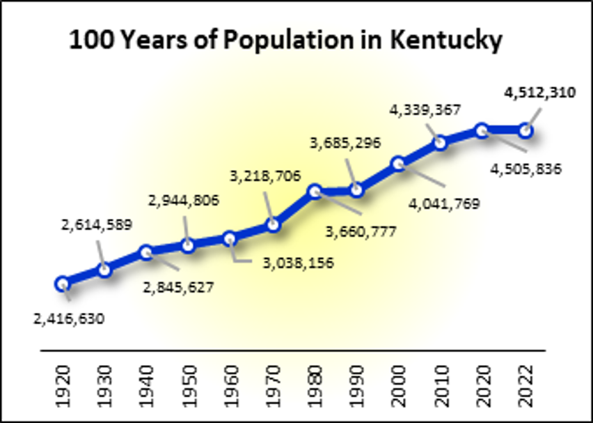
100 Years Population
Every 10 years, the U.S. Census Bureau conducts the Decennial Census. This is a count of all inhabitants in the United States. Required by the U.S. Constitution, it was first conducted in 1790. Over the decades, the Decennial Census has seen many changes. Most recently, the Census Bureau created the option to respond online.
To see the self-response rate (how many responded online or by phone/mail) for your county, visit the 2020 Census Response Rate Map at:
https://www.census.gov/library/visualizations/interactive/2020-census-self-response-rates-map.html
The official population counts are from the Decennial Census or the Census Bureau’s population estimates.
(While population data are available from the American Community Survey, they are NOT the official population figures.) To find out more about the history and changes in the Decennial Census, go to: https://www.census.gov/history/www/through_the_decades/overview/
County Data Sheets
To find your county, click on the file that contains your county name. All counties are listed alphabetically.
To print your county, scroll down to it and print the current page(s) only. To print the entire series, print all pages in each file.
~ ~ Each Data Sheet is 1 Page Long ~~
EACH OF THE FILES CONTAINS 5 COUNTIES.
To view these files, you will need Adobe Acrobat.
East Extension Region
Adair, Bath, Bell, Boyd, and Bracken Counties
Breathitt, Carter, Casey, Clay, and Clinton Counties
Cumberland, Elliott, Fleming, Floyd, and Green Counties
Greenup, Harlan, Jackson, Johnson, and Knott Counties
Knox, Laurel, Lawrence, Lee and Leslie Counties
Letcher, Lewis, McCreary, Magoffin, and Martin Counties
Mason, Menifee, Morgan, Owsley, and Perry Counties
Pike, Pulaski, Robertson, Rockcastle, and Rowan Counties
Russell, Taylor, Wayne, Whitley, and Wolfe Counties
Central Extension Region
Anderson, Boone, Bourbon, Boyle, and Bullitt Counties
Campbell, Carroll, Clark, Estill, and Fayette Counties
Franklin, Gallatin, Garrard, Grant, and Harrison Counties
Henry, Jefferson, Jessamine, Kenton, and Lincoln Counties
Madison, Marion, Mercer, Montgomery, and Nelson Counties
Nicholas, Oldham, Owen, Pendleton, and Powell Counties
Scott, Shelby, Spencer, Trimble, Washington, and Woodford Counties
West Extension Region
Allen, Ballard, Barren, Breckinridge, and Butler Counties
Caldwell, Calloway, Carlisle, Christian, and Crittenden Counties
Daviess, Edmonson, Fulton, Graves, and Grayson Counties
Hancock, Hardin, Hart, Henderson, and Hickman Counties
Hopkins, LaRue, Livingston, Logan, and Lyon Counties
McCracken, McLean, Marshall, Meade and Metcalfe Counties
Monroe, Muhlenberg, Ohio, Simpson, and Todd Counties
Trigg, Union, Warren and Webster Counties
Data Source
Data from the 2010 and 2020 Censuses and the 2022 Population Estimates are from https://data.census.gov/
The 1920-1990 data are from the Census Bureau publication Population of States and Counties of the United States: 1790 to 1990 available at: https://www2.census.gov/library/publications/decennial/1990/population-of-states-and-counties-us-1790-1990/population-of-states-and-counties-of-the-united-states-1790-1990.pdf
