Eastern Kentucky: By The Numbers
![]()
Eastern Kentucky: By The Numbers provides profiles of secondary data for each of the 54 Appalachian counties in Eastern Kentucky.
Compiled from 18 different sources, data for more than 60 variables are organized across 10 thematic areas:
- Demographics
- Youth
- Income/Earnings
- Education
- Agriculture
- Employment
- Coal Employment
- Health
- Substance Abuse
- Poverty/Insecurity
Eastern Kentucky: By The Numbers is a collaboration between the Appalachian Center and the Kentucky: By The Numbers Cooperative Extension program run by Dr. Julie N. Zimmerman in the Department of Community and Leadership Development. Data for Eastern Kentucky: By The Numbers were compiled by Dr. Julie N. Zimmerman and Cameron McAlister. Additional resources and other issues of the Kentucky: By The Numbers data series are available at https://kybtn.ca.uky.edu/
County Data Sheets
To find your county, click on the file that contains your county name.
All counties are listed alphabetically.
~ ~ Each Data Sheet is 2 Pages Long ~ ~
To view these files, you will need Adobe Acrobat.
Adair Bath Bell Boyd Breathitt Carter Casey Clark
Clay Clinton Cumberland Edmonson Elliott Estill Fleming Floyd
Garrard Green Greenup Harlan Hart Jackson Johnson Knott
Knox Laurel Lawrence Lee Leslie Letcher Lewis Lincoln
McCreary Madison Magoffin Martin Menifee Metcalfe Monroe Montgomery
Morgan Nicholas Owsley Perry Pike Powell Pulaski Robertson
Rockcastle Rowan Russell Wayne Whitley Wolfe
Selected Maps
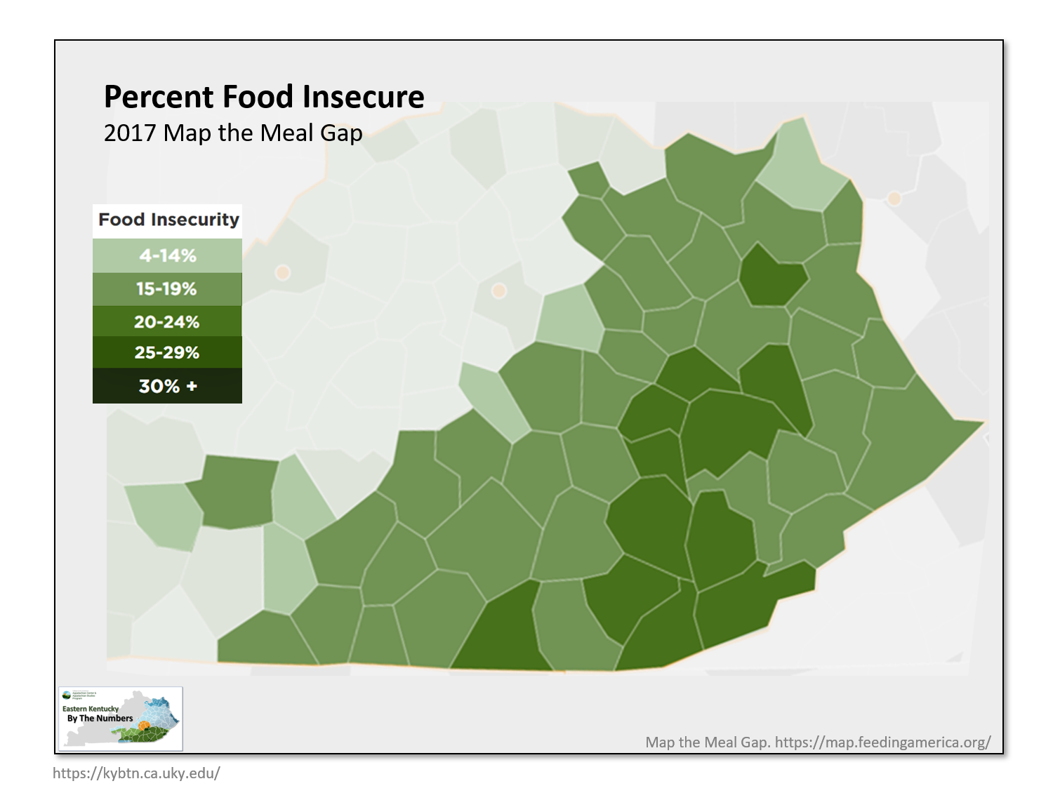
- Percent Food Insecure
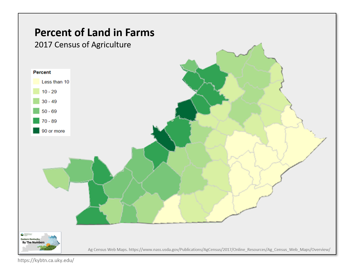
- Percent Land in Farms
- Median Household Income
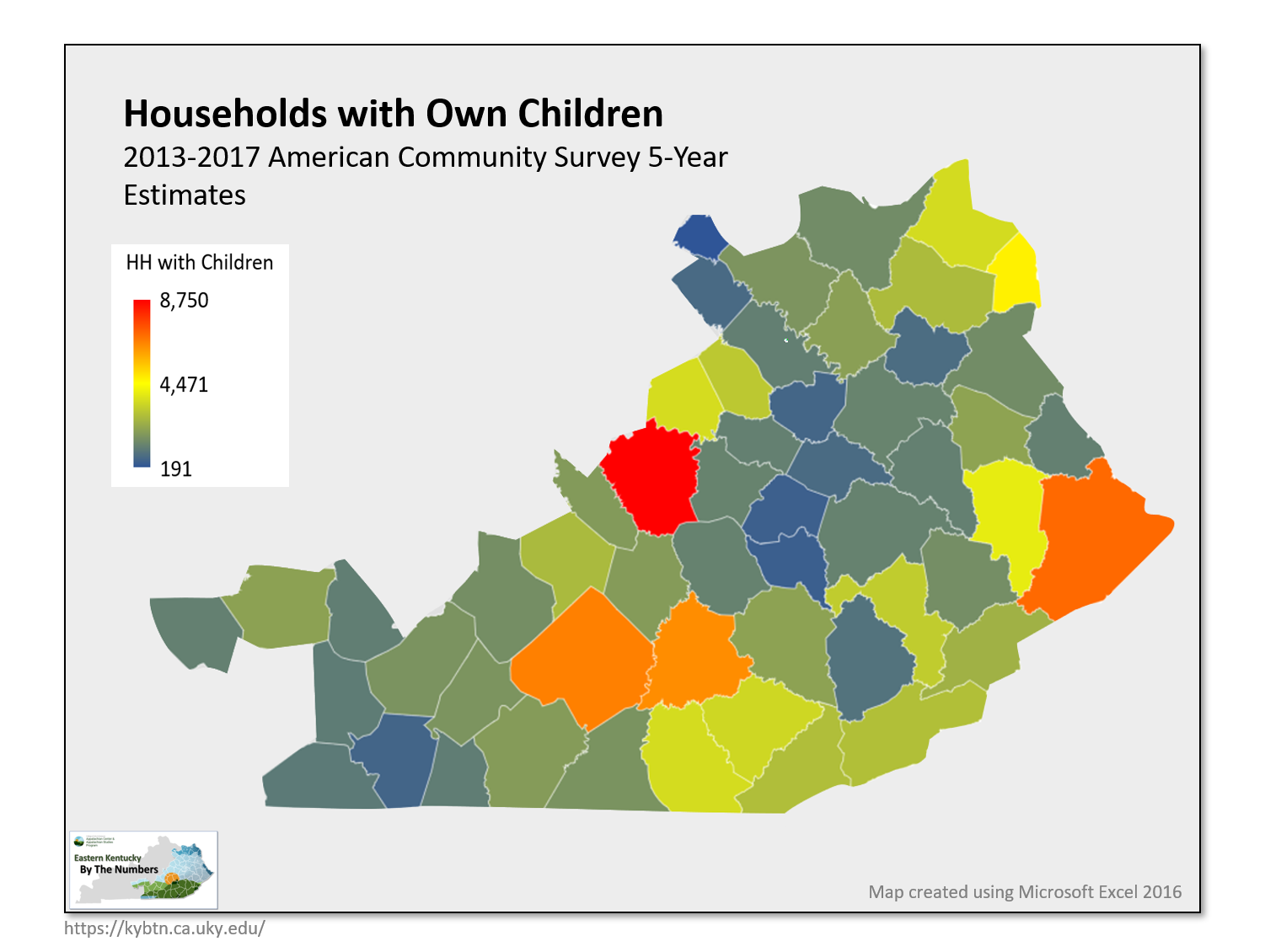
- Number of Households with Own Children
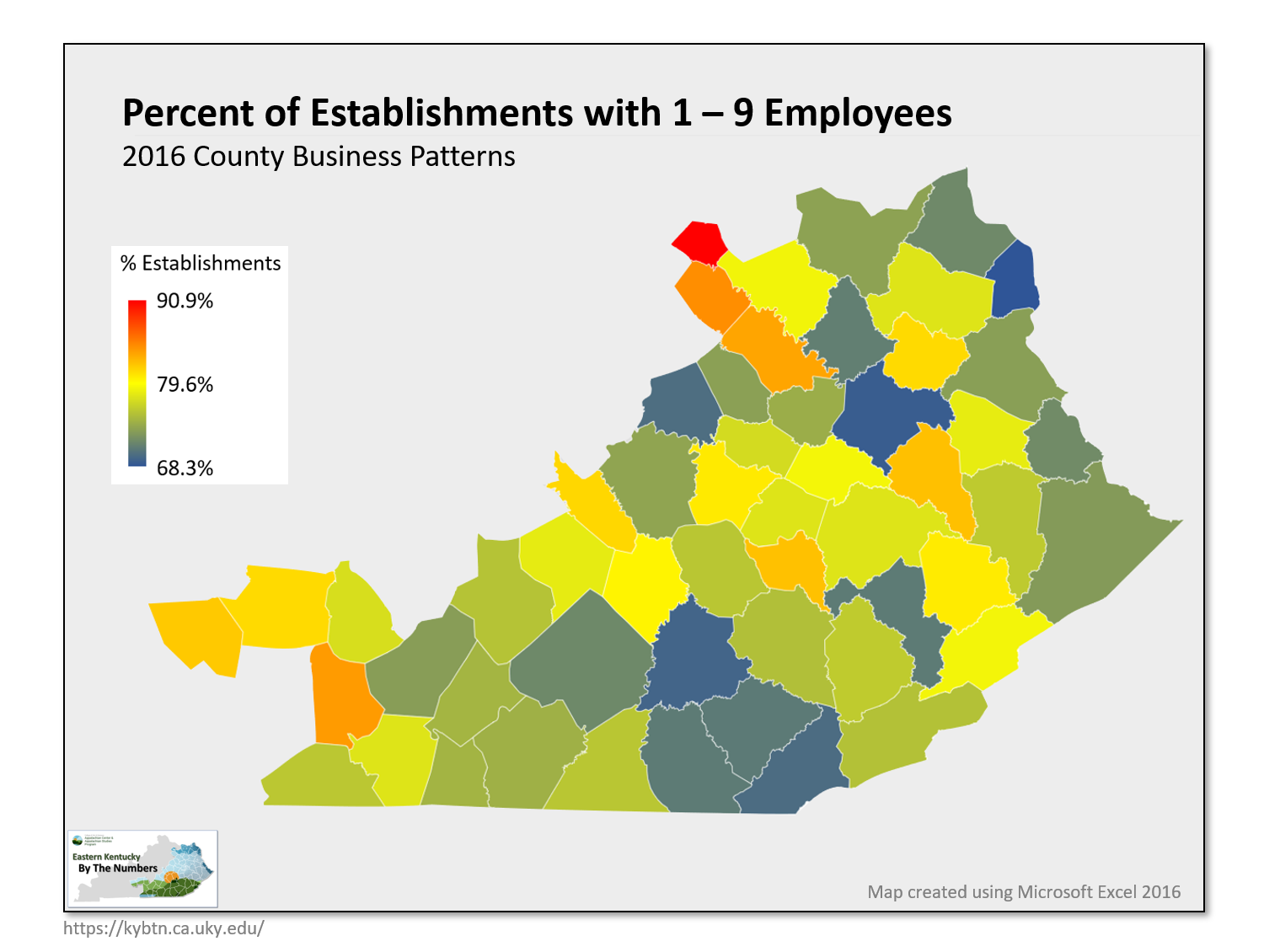
- Percent of Establishments with 1-9 Employees
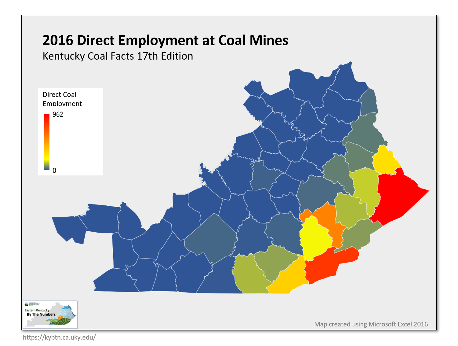
- Direct Employment at Coal Mines
- Percent of Adults Reporting a Time in the Past Year they Needed to See A Doctor but Could Not Because of the Cost
- All Maps Combined
Data Sources
2010 Decennial Census. U.S. Census Bureau. American FactFinder. https://factfinder.census.gov
2018 Population Estimates. U.S. Census Bureau. American FactFinder. https://factfinder.census.gov
Population Projections – Vintage 2016. Kentucky State Data Center. http://ksdc.louisville.edu/
2013-2017 American Community Survey 5-Year Estimates. U.S. Census Bureau. American FactFinder. https://factfinder.census.gov
2019 Early Childhood Profile. Kentucky Center for Statistics. https://kystats.ky.gov/
2017 Small Area Income and Poverty Estimates (SAIPE). U.S. Census Bureau. https://www.census.gov/programs-surveys/saipe.html
2017 High School Feedback Report. Kentucky Center for Statistics. https://kystats.ky.gov/
2017 Census of Agriculture. National Agricultural Statistics Service. U.S. Department of Agriculture. https://www.nass.usda.gov/Publications/AgCensus/2017/index.php
Regional Economic Accounts. Bureau of Economic Analysis. https://apps.bea.gov/itable/iTable.cfm?ReqID=70&step=1
County Business Patterns. U.S. Census Bureau. American FactFinder. https://factfinder.census.gov
NonEmployer Statistics. U.S. Census Bureau. American FactFinder. https://factfinder.census.gov
Kentucky Coal Facts. 12th Edition. Kentucky Energy and Environment Cabinet, Department for Energy Development and Independence, and Kentucky Coal Association. https://eec.ky.gov/Energy/News-Publications/Pages/Coal-Facts.aspx
Kentucky Coal Facts 17th Edition. Kentucky Energy and Environment Cabinet, Department for Energy Development and Independence, and Kentucky Coal Association. https://eec.ky.gov/Energy/News-Publications/Pages/Coal-Facts.aspx
Kentucky Health Facts. Foundation for a Healthy Kentucky. http://www.kentuckyhealthfacts.org/
County Profiles for Drug‐related Inpatient Hospitalizations and Emergency Department Visits. Kentucky Injury Prevention and Research Center (KIPCR). http://www.mc.uky.edu/kiprc/pubs/overdose/county-profiles.html
Kentucky Resident Drug Overdose Deaths by County of Residence, 2013‐2017. Kentucky Injury Prevention and Research Center (KIPCR). http://www.mc.uky.edu/kiprc/Files/drug/2018/KY_OD_DeathsxCounty_2013‐2017.pdf
Map the Meal Gap. Feeding America. http://map.feedingamerica.org/
Kids Count Data Center. https://datacenter.kidscount.org/
